Subscribe To
OUT MAGAZINE
OUT MAGAZINE


I was half-distracted by a handsome man when I took the Classic Harbor Line's American Institute of Architect's boat tour around Manhattan earlier this summer. He was tall and lean and olive-skinned and wore a half-cocked baseball hat with a cock-sure smile. He was at the bow of the boat and he kept looking over his shoulder, toward where I was, on the port side. He looked imploring one minute and disdainful the next. Was he looking at me? He definitely looked like he knew how to fuck. But he was also with his father and I was with my mother and he couldn't have been more than 23, so I put away my lech goggles and turned back to the guided tour already in progress.
Though I've lived in New York City for almost a decade, I, like so many New Yorkers, rarely take the time to learn about my city, and it seemed to me there's are few better ways to do it than on a boat, floating around the island, the river mist and wind keeping you cool under a summer sun. And I was right.
We had already departed Chelsea Piers and passed the glass and steel wonders that are Barry Diller's IAC headquaters, the Standard Hotel and the glitzy Perry Street towers, another recent addition to a Westside skyline once dominated by brick and mortar. Don't get me wrong, there's still plenty that remains: Richard Meier embraced the neighborhood's industrial past when he made the 60s-era Westbeth building, and the former Federal Archive Building, now filled with apartments, is a burst of red cinder. But the city's changing face, and the neighborhood's changed demographics, are in full display for those coming down the river.
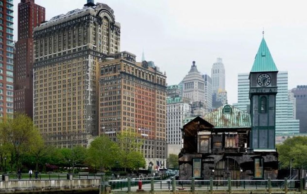
The Lenape Indians used to travel these waters, a much cleaner river splashing into their canoes as they traveled from village to village, trading pelts and shells. It was they who called Manhattan island "Manna-hata." They referred to lower Manhattan as "Sapokanikan" and used it as a base camp for a sprawling, multi-borough territory dubbed Lenapehoking, "in the land of the Lenape." Now the area is lower Manhattan, an area built up and out by landfill and is home to the world's seemingly unstoppable financial engine. The new World Trade Center is the steeple of this glittering shrine to economic success, but pockets of history remain. For example, City Pier A, a port first built up for civilian use in the late 1800s and whose tower resembles a Dutch town hall, due in part to the city's large population of immigrants from that region. This place wasn't called "New Amsterdam" for nothing.
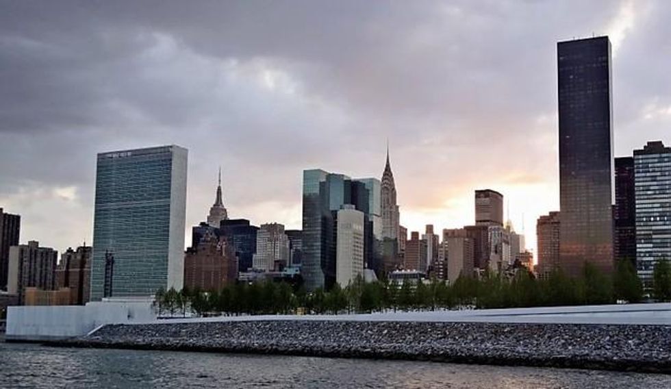
The Statue of Liberty greeted us with an unremarkable yet welcoming stare as we moved into New York Harbor. The neoclassical beauty was still being repaired from Sandy damage, but stood as tall and proud as she did when France gifted it to the States in 1886. This was when neighboring Governor's Island was still an army base. Later, in 1966, G.I. would be transferred to the Coast Guard, and it would still be three decades before it became civilian territory. On this day, the daily dose of visitors were being deposited at the landing just north of the new New York Harbor School, a public institution that's the island's first permanent inhabitant in over ten years. I glanced toward the cutie up front. I could swear he had been looking over his left shoulder at me, but now his eyes were straight ahead, on the East River.
The Woolworth and Municipal buildings stand tall, as they have since 1913 and 1914, respectively, but then there's also Frank Gehry's contrarian residential tower at 8 Spruce Street and, below that, the hideous William Beaver House. The steady, stony Brooklyn Bridge remains a constant, and now stands mightily above the recently renovated, and splendid, Brooklyn Bridge Park. It's there that you'll find Jane's Carousel, a 1922 merry-go-round renovated by the eternally fabulous Jane Walenta, wife of developer David, the man who transformed Soho and Dumbo into the neighborhoods they are today.
We pass The Manhattan Bridge, all steel and wires, and to the left there's East River Park, a space turned "public" when Robert Moses and his crew cleared out the homeless and the riff-raff. To our right, in Brooklyn, new glass towers rise above Williamsburg and the old Domino Sugar Factory first built in 1856. That lot too is being converted into pricey residential towers. Parks, shops and restaurants will also be added to the complex to become what developer's are describing as "the Highline of Brooklyn." Luckily, the giant, yellow Domino sign will remain. Kitschiness has its value.
There's no kitchiness whatsoever at Roosevelt Island. Called Minnehanonck by the Lenape, and once a private estate, the land would go on to house smallpox patients, to house prisoners, and as host to an insane asylum. Many relics from the olden days still exist, like the Chapel of the Good Shepherd, built in 1889, but since 1969 it has been mostly residential and the island is dominated by apartment buildings. At its southern most point, though, there's a new jewel, Four Freedoms Park.
Erected at the southern most tip of Roosevelt Island, this white granite monument was designed by Louis Kahn in honor of Franklin D. Roosevelt, the 32nd president. The name "Four Freedoms" comes from Roosevelt's landmark 1941 State of the Union address, the one in which he outlined the four freedoms every human deserves: freedom of speech and worship, freedom from want and freedom from fear. Kahn designed the park in 1972, but it wouldn't be completed and opened until 2012, 38 years after Kahn's death, and 68 after FDR's.
I'll admit, I zoned out a bit as we went by familiar Mid-town and the Upper East Side. I listened only a little when the Chrysler Building and Empire State building were discussed, and I very nearly missed Gracie Mansion, the official home of the mayor, though not the one Michael Bloomberg uses. His penthouse is far nicer than public housing. Speaking of, my ears perk up after we pass Randall's Island and are in the Harlem River. The landscape, made up of public house, is less inspiring, but no less educational. Riverbend Houses, designed by landmark architects Lew Davis and Sam Brody in the late 1960s, come into view as we approach 138th Street's riverside.
These were an attempt to lighten up Brutalist architecture with bursts of colorful "skyways" that were meant to be "streets in the sky." The buildings were supposed to give residents a more airy street scape, but the residents weren't interested in hanging out in exposed hallways and the grand design was later, after some fan fair, deemed a failure. Or, at the very least, an eyesore, just like so many buildings that line this stretch of Manhattan. River views were not yet en vogue -- the city was still all about Central Park -- but today developers are sinking their teeth into land abutting the river, eager to take the view from places like Riverbend and the Harlem River Houses, the first public housing to be built for black people and with federal funds.
The landscape reverts back to its pre-colonial days as we approach Manhattan's northern tip. Rocky, jagged cliffs topped with robust, leafy trees loom large and strong and high, providing a base for generations of daredevils willing to climb back up after a jump. The more cheeky ones, we're told, spend their time at the top, mooning tour boats like ours. We pass through by Hell Gate, a narrow straight known to take ships and sailors back in the day, and under bridges linking tiny Manhattan Island to the sprawling Bronx, and then we're back on the Hudson, across from the Cloisters, a museum and complex donated by John D. Rockefeller in 1938, and remains today one of the city's most beautiful and isolated sights to see.
The island is once again lush. This is where the truly rich used to set up shop, away from downtown and, later, Central Park. If the park was the suburbs, this was the country, and on this summer day the trees are in full plumage, allowing fantasies of the Lenape to reappear as we pass Riverbank State Park and Grant's Tomb, a 19th Century circular structure containing sarcophagi of the 18th president and his wife. It's not too long before we're told about the Soldiers' and Sailors' Monument, another circular structure completed a few year's after the Grant memorial, in 1902.

Soon enough the 79th Street Boat Basin is behind us and we are directly west of Roosevelt Island at this point, and Midtown's glitz steals the show. Trump Place, the Time-Warner and Heart buildings can be seen through slits of steel and glass. The Intrepid, a former air craft carrier, is obviously easier to see, and those fantasies of Lenape Indians are replaced by Seamen as I marvel at the sheer size of this floating city. It's a city docked next to another city, both ultimately small but daunting all the same.
Then, before I know it, we're beside Hudson River Park and Chelsea Piers and pulling back into the dock. Could it be over already? Was that a three hour tour? And what happened to that cocky young man? He was gone, lost in the city's shuffle, between its buildings and historic landmarks. And soon enough so was I.
For more on the AIA Architectural Cruise, check out their website. And don't fret, they offer tours all year-round, and there's probably an even better view of Northern Manhattan's rough terrain in the winter.


Latest Stories